|
1995 Pacific hurricane season
| |
 | |
|
First system formed
|
May 21, 1995
|
|
Last system dissipated
|
September 6, 1995
|
|
Strongest storm
|
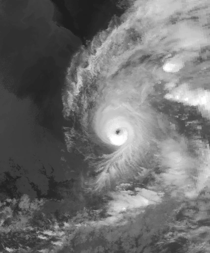
Juliette – 930 mbar (hPa) (27.47 inHg), 150 mph (240 km/h) (1-minute sustained)
|
|
Total depressions
|
11
|
|
Total storms
|
10
|
|
Hurricanes
|
7
|
|
Major hurricanes (Cat.3+)
|
3
|
|
Total fatalities
|
124 direct
|
|
Total damage
|
$31 million (1995 USD)
|
The 1995 Pacific hurricane season was the least active Pacific hurricane season since 1979. Of the eleven tropical cyclones that formed during the season, four affected land, with the most notable storm of the season being Hurricane Ismael, which killed at least 116 people in Mexico. The strongest hurricane in the season was Hurricane Juliette, which reached peak winds of 150 mph (240 km/h), but did not significantly affect land. Hurricane Adolph was an early-season Category 4 hurricane. Hurricane Henriette brushed the Baja California peninsula in October.
The season officially started on May 15, 1995, in the Eastern Pacific, and on June 1, 1995, in the Central Pacific, and lasted until November 30, 1995. These dates conventionally delimit the period of each year when most tropical cyclones forms in the northeastern Pacific Ocean. The season saw eleven tropical cyclones form, of which ten became tropical storms. Seven storms attained hurricane status, of which three acquired major hurricane status. There were fewer tropical storms than the average of 16, while the number of hurricanes and major hurricanes were slightly below average.
Season summary[]

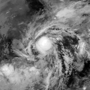
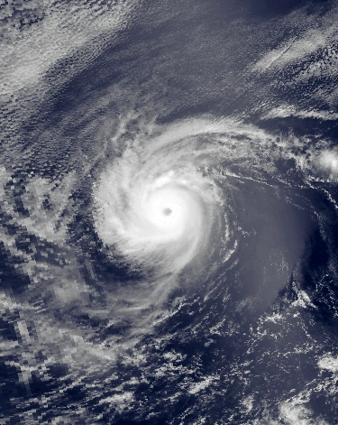
Tropical Depression Erick (left) and Tropical Storm Flossie (bottom-center) on August 7
The seasonal activity during 1995 was below normal, and marked the first of several seasons with lower than normal activity, a trend that persists to this date. Four tropical cyclones affected Mexico: first, Hurricane Flossie passed within 75 miles (120 km) of Baja California, producing moderate winds and killing seven people. Afterwards, Tropical Storm Gil dropped heavy rainfall in Southern Mexico early in its life, though caused no damage. Hurricane Henriette later made landfall near Cabo San Lucas with winds of 100 mph (160 km/h), resulting in moderate damage but no deaths. Finally, Ismael struck the state of Sinaloa as a minimal hurricane. Offshore, fishermen were caught off guard by the hurricane, causing 57 of them to drown. On land, Ismael destroyed thousands of houses, leaving 30,000 homeless and killing another 59. Both Hurricanes Flossie and Ismael also produced moisture and localized damage in South Western United States.
Activity in the Central Pacific Ocean was below active as well. No tropical storms formed in the basin. For the first time in four years. Barbara was the only tropical cyclone to exist within the basin, but it formed in the Eastern Pacific. It entered as a weakening tropical storm, and quickly dissipated, without affecting land. It was the least activity in the basin since 1979, when the basin was completely quiet, as no storms entered the basin that year.
Storms[]
Eleven Tropical Cyclones, including one Tropical Depression that failed to attain tropical storm status, developed in the Eastern Pacific Ocean in 1995.
Tropical Depression One-E[]
| Tropical depression (SSHWS) | |||
|---|---|---|---|
| |||
| Duration | May 21 – May 23 | ||
| Peak intensity | 35 mph (55 km/h) (1-min) 1005 mbar (hPa) | ||
A westward-moving tropical wave entered the Pacific Ocean in mid-May. Convection within the disturbance became more concentrated and organized on May 19 while the wave was located a short distance south of the Gulf of Tehuantepec. The deep convection concentrated around a low-level circulation with expanding outflow, and the system developed into Tropical Depression One-E on May 21, while located about 400 mi (645 km) south of Manzanillo, Mexico. Initially the depression was forecast to strengthen to reach winds of 55 mph (90 km/h) as it moved westward under the influence of a high-pressure system to its north. Outflow increased as the storm moved through an area of warm waters and a favorable upper-level environment, and two satellite classifications indicated the system was at tropical storm status around nine hours after forming. Despite the favorable environment and satellite classifications of tropical storm status, the depression failed to organize further. The convection and organization continued to decrease, and on May 23 the depression dissipated.
While it was developing, locally moderate to heavy rainfall fell across southern Mexico along the disturbance's northern periphery, with rainfall totals peaking at 5.18 inches (132 mm) at Vallecitos/Petatlan.
Hurricane Adolph[]
| Category 4 hurricane (SSHWS) | |||
|---|---|---|---|
| |||
| Duration | June 15 – June 21 | ||
| Peak intensity | 130 mph (215 km/h) (1-min) 948 mbar (hPa) | ||
An area of disturbed weather associated with a tropical wave organized off the southwest coast of Mexico during the middle of June. Banding features developed as a circulation persisted on the northeast side of its deep convection, and the system developed into Tropical Depression Two-E on June 15. Under weak steering currents, the depression moved slowly northward, and with deep convection organizing near its center, the depression intensified to Tropical Storm Adolph on June 16. Located in an area of warm waters, Adolph exhibited a well-defined outflow pattern, and rapidly strengthened to attain hurricane status on June 17 as a banding-type eye developed. Hurricane Adolph turned to the northwest and attained major hurricane status late that same day. The small eye of the hurricane continued to organize, as very deep convection surrounded the eyewall, and Adolph reached its peak intensity of 135 mph (215 km/h) on June 18, making it a Category 4 hurricane on the Saffir-Simpson scale. Shortly thereafter, the storm weakened, as the upper-level environment became more hostile, and the system moved over progressively cooler waters. On June 19, Adolph turned to the west, and degenerated back into a tropical storm later that day. On June 20, the storm weakened to a tropical depression, and on June 21, Adolph began to dissipate as its center became devoid of deep convection.
As Adolph moved north towards Mexico while about 290 mi (465 km) off the coast, the Mexican government issued a tropical storm warning and a hurricane watch from Punta Tejupan to Cabo Corrientes. When the storm turned to the northwest and later to the west, the government discontinued the warnings as it was determined the storm would not be a threat to land. No damage or casualties were reported.
Hurricane Barbara[]
| Category 4 hurricane (SSHWS) | |||
|---|---|---|---|
| |||
| Duration | July 7 – July 18 | ||
| Peak intensity | 140 mph (220 km/h) (1-min) 940 mbar (hPa) | ||
A few days later, on June 24, another weak tropical wave moved off the coast of Africa. It moved steadily westward through the Atlantic Ocean without any development, and entered the eastern Pacific Ocean on July 5. At this point, convection developed along the wave axis, and the system gradually organized. A circulation developed as it passed through an area of warm waters, and the system developed into Tropical Depression Three-E on July 7, while located about 600 miles (965 km) south of Manzanillo, Colima. Although the outer rainbands warmed slightly in the hours after the formation, the convection near the center deepened further with favorable upper-level outflow, and the depression strengthened into Tropical Storm Barbara early on July 8. Barbara steadily intensified, and following the development of a ragged eye that night, Barbara strengthened into a hurricane on July 9, while located about 700 miles (1130 km) south of the southern tip of Baja California.
After moving into an area of light vertical shear and warm water temperatures, Barbara quickly intensified to reach major hurricane status on July 10. The eye continued to become better organized, and Barbara attained winds of 135 mph (215 km/h) later on July 10. After maintaining its intensity for 24 hours, increased wind shear from an upper-tropospheric trough degraded the appearance of the deepest convection, and the eye became obscured from satellite images. After weakening to a 115 mph (185 km/h) hurricane, Barbara maintained its intensity for 30 hours before moving into an area with very warm waters and a favorable upper-level environment. On July 13, the hurricane re-organized, a distinct eye again developed, and Barbara strengthened to reach its peak intensity of 140 mph (225 km/h) later that day. Barbara continued westward under the influence of a subtropical ridge to its north, and began to steadily weaken on July 14 as it moved into an area of cooler water temperatures. The hurricane degraded to a tropical storm on July 16, and a day later it deteriorated to a tropical depression. As a depression with little to no convection near its center, Barbara continued west-northwestward until dissipating on July 18 while located 720 mi (1160 km) east-southeast of Hilo, Hawaii. Barbara remained away from land for its entire lifetime, and it did not cause any damage or deaths.
Hurricane Cosme[]
| Category 1 hurricane (SSHWS) | |||
|---|---|---|---|
| |||
| Duration | July 17 – July 22 | ||
| Peak intensity | 75 mph (120 km/h) (1-min) 985 mbar (hPa) | ||
.JPG)
As Barbara moved away from land, another area of disturbed weather moved off the coast of Central America on July 11. Moving westward, this area slowly organized, and developed a low-level circulation on July 15. The convection developed into curved rainbands, and based on Dvorak classifications of 35 mph (55 km/h), the National Hurricane Center estimated that the system developed into Tropical Depression Four-E on July 17, while located about 400 mi (645 km) south-southeast of the southern tip of Baja California. As the depression was situated in an area with warm waters and moderate upper-level outflow, the system was forecast to slowly intensify to a 50 mph (80 km/h) tropical storm. Initially, the depression followed the forecasts, and it intensified into a tropical storm about 30 hours after developing, receiving the name "Cosme". Cosme was expected to strengthen only slightly due to predicted cooler waters and increased shear.